
Kenner ZIP Directory Coverage
The clearest standard Kenner-associated delivery routes are 70062 and 70065. Other numbers need more care. Archived USPS grouping tables associate 70063, 70064, and 70097 with Kenner, but the research did not find a static current page that classifies every use. Census geography also shows ZCTA 70003 intersecting Kenner. That statistical overlap is not the same as a USPS promise that each address uses Kenner as its postal city.
| ZIP | Kenner relationship | Postal reference | Search caution |
|---|---|---|---|
| 70062 | Central and southern Kenner-associated delivery addresses | Kenner Post Office on Williams Boulevard | Verify the exact street through USPS |
| 70065 | North Kenner-associated delivery addresses | North Kenner Post Office on West Esplanade | North and south are shorthand, not legal lines |
| 70063 | Kenner grouping or auxiliary code in USPS DMM material | Exact current classification not found on a static page | Do not assume it is a standard residential ZCTA |
| 70064 | Kenner grouping or auxiliary code in USPS DMM material | Exact current classification not found on a static page | Use address-level confirmation |
| 70097 | Code associated with Kenner in archived USPS grouping | Exact current classification not found on a static page | Treat as address-specific |
| 70003 | Census ZCTA intersects the Kenner city boundary | Postal city label can differ | ZCTA overlap does not define city membership |
| 70094 | Older material used a South Kenner grouping | Historical Westwego-area reference | Current status was not verified |
This ZIP code directory is deliberately cautious about auxiliary and historic codes. The exact address-to-code result belongs to USPS. Use the table to choose searches and spot conflicts, not to assign a household to the Kenner city limits.
Verify a Kenner ZIP Address
The official USPS ZIP Code Lookup offers three useful routes. By Address needs a street address and can accept a company. By City and State suggests codes for the place. Cities by ZIP reverses the question and returns postal city information for a code. Preserve both the submitted form and standardized result, including direction, suffix, unit, ZIP5, and ZIP+4.
| USPS mode | Fields | What it answers |
|---|---|---|
| By Address | Street address required; company optional | Current standardized delivery form and code |
| By City & State | City and state | Current ZIP suggestions for the postal place |
| Cities by ZIP | ZIP | Current postal city list tied to that code |
USPS notes that updates can take time to appear. Date the result, especially if an address change, route update, or new construction may be involved.
Kenner ZIP 70062 Postal Anchor
ZIP 70062 is tied to the Kenner Post Office at 2300 Williams Boulevard, Kenner, LA 70062-9998. USPS lists the office phone as 504-466-3866 and hours of 8 a.m. to 4:30 p.m. weekdays, plus 9 a.m. to noon Saturday. Those details identify a postal facility, not the full geographic outline of the delivery ZIP.
The official Kenner Post Office listing appears in the captured image below.
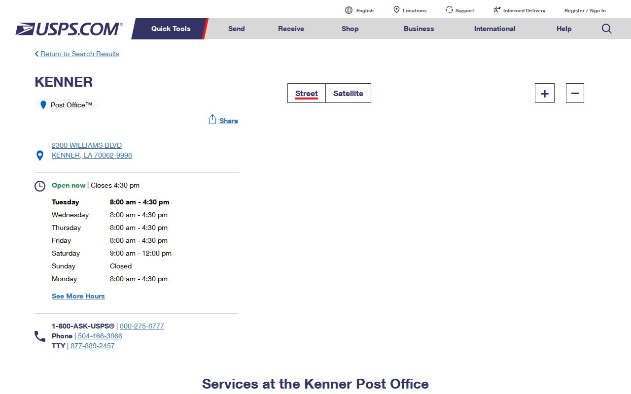
Use the office as a reliable 70062 reference point, then use By Address for any home, unit, or business under study.
Kenner ZIP 70065 in Context
ZIP 70065 is the clearest North Kenner-associated standard route. USPS search material identifies the North Kenner Post Office at 390 West Esplanade Avenue, Kenner, LA 70065-2577. The research did not locate a stable direct USPS location page for that branch, so the ZIP directory should not add unsupported office details.
“North Kenner” is useful shorthand, not a municipal or statistical boundary. Confirm the street itself. A route can cross other mapped layers, and a voter precinct, assessor ward, Census area, and postal code may all draw different lines.
Find Kenner Residents by ZIP
A Kenner ZIP code directory can narrow a lawful personal search, but official tools do not all work the same way. The Louisiana Voter Portal accepts ZIP in its name and address routes. The Assessor does not. JeffMap exposes ZIP as an address-layer attribute, while Census uses ZCTA for statistics. Follow the tool's own geography rather than forcing one ZIP filter across every record set.
- Standardize the full street address through USPS and record ZIP5 and ZIP+4.
- Use the voter address form with ZIP, address, apartment or lot, and city when a registration check is appropriate. A protected record may not appear.
- Search the Assessor by property address, parcel, or subdivision because its form has no ZIP control. Confirm the municipal and legal land record there.
- Locate the address point in JeffMap and retain its ZIP, grid, parcel, and city-boundary context as separate fields.
- Use Census ZCTA only for area statistics and overlap. Do not use it to identify a person or decide the postal route.
After a code narrows the area, the Kenner street directory gives the address-to-parcel and deed sequence. That shift matters because a ZIP-wide result is too broad to establish a specific home.
Kenner Portals That Accept ZIP
The voter address form is the most direct resident-record route with a ZIP field. Its inputs are ZIP, address, apartment or lot, and city. The voter name route uses first name, last name, ZIP, birth month, and birth year. Public voter data remains subject to Louisiana confidentiality rules, and a registration match is not proof of present physical presence.
| Official tool | ZIP-related field | Proper role |
|---|---|---|
| USPS By Address | ZIP and ZIP+4 output | Current delivery normalization |
| Louisiana Voter Portal | ZIP input on address and name routes | Current registration search with protected omissions |
| JeffMap / GIS | ZIP attribute with address, grid, and parcel ID | Mapped location context |
| Jefferson Parish Assessor | No ZIP input | Search address, parcel, or subdivision instead |
| Census data | ZCTA geography | Statistical profile and overlap |
A purchased Louisiana voter file can carry residence ZIP5 and ZIP4 plus district fields, but it is dated data with statutory access rules. Keep the purchase date and file layout. Never merge an old list with a current address without matching dates.
Check Kenner Auxiliary ZIP Codes
Archived USPS Domestic Mail Manual lists from 2005 and 2011 group 70063, 70064, and 70097 with Kenner-related entries. They establish historical postal groupings. They do not prove the present residential, PO-box, or other classification for each number. The research found no complete static current USPS classification list for them.
A safe result says that the code appeared in the dated grouping and that the current address must be checked. Do not label a code “PO boxes only” or “unique” without a current authoritative return. The same restraint applies to 70094, which older material tied to “South Kenner” alongside Westwego-area references.
Insider check. When an auxiliary Kenner ZIP appears, run the whole address through USPS instead of assigning it to a neighborhood from an old grouping.
Kenner Addresses Before ZIP Codes
Many Jefferson Parish land records predate ZIP codes. For an older Kenner address, search the street, subdivision, block, lot, and legal description rather than expecting a modern postal code. Historical place terms such as Kennerville, Cannes Brulee, Oakland, Belle Grove, and Pasture can uncover deeds, maps, directories, and newspapers missed by a current city-and-ZIP search.
The 1926 and 1939 Sanborn sheets can compare a former building footprint with today's parcel map. Airport growth beginning in the 1940s and later subdivision development changed the way locations were described. Preserve the old wording in the research log, then add the modern standardized address as a separate field.
Regional directories and the Jefferson Parish Library newspaper archive may index a person under a road, plantation, business, or community name instead of Kenner. The 1927 School Census and parish historical surveys offer another dated place check. When the old source yields a lot and block, carry those fields into the Assessor subdivision search and JeffMap. That bridge is stronger than adding a modern ZIP to a record that never used one.
Kenner ZIP and City Limits
A ZIP is a postal delivery construct. A Census ZCTA is a statistical approximation. Kenner's city boundary is a municipal line, and parcel, ward, precinct, and zoning layers serve other purposes. The 2020 Census profile reports 66,448 people for Kenner and shows the city intersecting ZCTAs 70003, 70062, and 70065, but that does not turn every point in those ZCTAs into a Kenner postal address.
This mismatch explains a common false result. A Kenner address may use a postal city label that differs, or a code associated with Kenner may extend beyond the city. The Assessor property card and JeffMap city boundary resolve the land context. USPS resolves current delivery. Census resolves statistics. The ZIP directory should keep those answers in separate columns.
- ZIP and ZIP+4
- A ZIP is the five-digit delivery area. ZIP+4 adds four digits that narrow the delivery segment.
- PO-box ZIP
- A code used for post-office boxes rather than a normal mapped residential delivery area.
- Unique ZIP
- A code assigned to one large organization or recipient instead of a broad neighborhood.
- Carrier route
- A postal delivery path within a ZIP. It is operational mail geography, not a city boundary.
Do not overread a ZIP. A code, tax owner, voter match, or deed party alone does not prove that someone currently lives at a Kenner address.